So far in this series I have concentrated on the small area that gave the Dingle its name. To cover the wider vicinity that later became known as the Dingle, I’ll look at what brought the people here – the industry of Toxteth Park.
Fishing and Peat digging in 14th century Toxteth
As Toxteth had been a Royal Hunting Park from the dawn of the 13th century, even agriculture was limited. Foresty was present of course, Edmund Crouchback ordered oaks from his Toxteth Park to used in the building of Flint Castle for his brother King Edward I. In 1346, the second Henry of Lancaster, made an inventory of his late father’s income from Liverpool. A fishing-weir and peat-holes were also included for Toxteth Park:
Since 1327 the lord has apparently established a fishing-weir near Toxteth Park which brings him in 6s. a year ; and peat-holes in Toxteth yield 6s. 8d. per annum.
Commercial fishing continued beyond the 18th century. Evidence of Toxteth fishing grounds can be seen on a map of the Toxteth Park estate made in 1756 (search for The produce of Rimmer’s farm on Part Two of this series).
The peat collection was the 30 acres of Moss (peat/turbary) from area known as the Moss Lake. A great part of what we now think as central Liverpool was actually Toxteth Park at this point, including the Moss Lake. Below the turbary at the Moss Lake was the Great Heath. At a later point, Heath had become common pasture for the town of Liverpool. Both the Moss and Great Heath were then incuded within the Liverpool boundary. The boundary of Toxteth then moved to Parliament Street. (See my post Discovered: The ancient boundaries of Toxteth Park).
The mills of Toxteth Park
The history of milling in Toxteth Park is quite obscure. The limited information that is available is confusing in some parts, and wrong in others. Here is my attempt to get to provide a more accurate history, and one that is hopefully a lot easier to follow.
Although this section concentrates on wind mills and water mills from the 17th century on, milling may have been carried out in Toxteth Park since the Neolithic period. Evidence of this was found when excavating the lake for Sefton Park in the 1870s. The discovery was possibly the earliest known evidence of milling in Liverpool. This was a Bullan, or Bullaun stone. It was found on the bed of the brook that formed the lake. Perhaps this belonged to the same community who made the nearby Calder Stones burial chamber?
Bullan Stones.
An interesting British specimen of a double cup-hollowed stone, now in the collection of Mr. Bennett, Stones, was discovered, about 1870, while excavating the bed of a brook for making the lake in Sefton Park, Liverpool, part of the ancient Forest of Toxteth. The stone is a rolled boulder of red granite, measuring 1 foot 6 inches by 1 foot. Upon one of its sides, a natural smooth tabular surface, have been cut two hollows ; one being circular 8 inches in diameter and 5 inches deep, and the other of oval form about 6 by 5 inches and 4 inches deep. Upon the sides of the cups the tool marks arc perfectly clear and distinct ; but the bottoms of the hollows are worn smooth by use. This, as well as several larger boulders of grey granite, was excavated from drift or clay overlying the bed rock…
By its discovery we are placed in possession of a specimen that is not only unique in this part of the country, but that, as the only archaic milling relic of the district, may be regarded as the earliest known corn mill of Liverpool.
Note: I came about the story of this stone while I researching this post. I was amazed I had never heard of it before. If it was the same age of the Calder Stones, it would be extremely important. I discovered it was donated to the museum in 1897, after that no further information can be found. I contacted a leading archaeologist, and then National Museums Liverpool. Surprisingly they were unaware of its existence. It appears the stone had been classified into the wrong museum collection, and then lost to the records. The museum are looking into at present and I will provide an update when I have more information.
Early 17th century We now return to the Puritan settlers of Toxteth Park (from the late 1680s). In c. 1615 Edward Aspinwall took a lease of Park Yate House, Toxteth Park, with 50 acres and a mill, formerly held successively under Lord Derby and Sir Richard Molyneux by Giles Brooke, alderman and merchant of Liverpool, who died in 1614. Edward was cited in 1619/20 by members of the Brooke family seeking to uphold their rights to this property: it was said that under Edward’s tenancy it had been ‘much improved’.”
“HORROCKS OF TOXTETH. William Horrockes of Toxteth Park, yeoman, in April, 1614, made a claim in the Lancashire Chancery court, stating that John Bird of Liverpool, gentleman, who was seised for life and 25 years following of a piece of land called Neene Acres, gave the same to him for four years from November, 1613. Possession, however, had not been given, and he desired an order of the court to obtain it. (Pal. of Lane. Chancery Bills, 2).
Thomas Hey, who had land near Pyliard Yate in Toxteth Park, in 1625-6, made a claim against John Wharrocks, who had married Sarah formerly wife of Henry Croft, who had been a servant of Alexander Molyneux, esq.
Stray Notes, Historic Society of Lancashire and Cheshire
Shown below is a section of William Yates’ map of Lancashire from 1786. Just below St. James’ church can be see two windmills. These are either side of Park Road (named Park Lane at this period, as was Aigburth Road). A stream ran between the mills, and three large bodies of water can be seen. If you follow the stream to the Mersey there is another mill, this time water-powered as indicated by the waterwheel symbol.
We begin with the mill closest to the church.
Section of William Yates’ map of Lancashire from 1786
The mill that gave its name to Mill Street
After close inspection of Robert Griffiths history of Toxteth Park (1907), it becomes apparent that he often had very limited resources for some of the subjects. Sometimes it is obvious that certain sections relied on just a map. Griffiths’ great gift was to take this solitary source and make the reader believe they were walking down the street as it was 100 years before. He chose to call the mill closest to the church ‘St. James Mill’ (looking at Yates’ map you can see why he picked this name).
Contrast Toxteth of to-day with Toxteth as our grandsires knew it, or even our fathers – what a change! Then, as you entered the park from Liverpool, commencing the ascent from Park Road at St. James’ Church, the first building on the right across the fields, in “Mill Lane,” was an old wooden windmill, a picture of which we give. This view is from an old drawing made in 1790. The mills to the right are those on the high land in Hope Street and that on Mount Quarry, from which in ancient times the stone was taken to build the Tower and other Liverpool buildings, but now used as a cemetery. The site of this mill is at present occupied by the Cemetery Chapel.
St. James’ Mill stood some way back from Park Road, on a spot which now forms the junction of Hill Street with Mill Street, just beside the footpath through the fields to the two buildings near the church. One of these buildings was probably the farm house which afterwards stood at the corner of Park Road and Upper Stanhope Street, and the other appears to have been a house of entertainment.
The structure that Griffiths called ‘St. James’ Mill’ is this one below. It’s by William Gawin Herdman (1805–1882), but copied from a view from 1790.
Coloured lithograph of Park Road Mill, Toxteth. The church is St James’ Church on St James’ Place, the spired church in the distance is St Thomas’ Church, Park Lane. Two tower mills can be seen in the distance, possibly Lime Street Mill, Liverpool. Text and image: millsarchive.org
Griffiths commissioned Joshua Fisher to copy this view, but left off the mill.
Fisher saved the full view for several pages later. Here it is, in all its rural glory.
The name ‘St. James’ Mill’ was probably an invention by Griffiths to aid its location, I have been unable to find another reference to that name. If it ever was called that, it was not it’s original name because it predated the church. It was probably just called the Toxteth windmill. It was this mill that gave it’s name to Mill Street.
Shown below is section of Horwood’s plan of 1803. The empty streets below are part of a failed development by Earl Sefton and Cuthbert Bisbrown. This new town, next to Liverpool, was named Harrington – after the family of Earl Sefton’s wife. Mill Street runs vertically, and where it is crossed by Hill Street is a windmill blocking the planned road (probably little more that ropes staked out at this point). I have coloured the mill red, the unamed road to the right is park Road. Another mill can be seen bottom right next to a reservoir, see Park Road windmill and watermill – Mather’s Dam.
To give some idea of the mill’s inconvenient location once the streets were laid out, I have done this Photoshop reconstruction.
Image: JIm Kenny
Because of its problematic location, it was demolished soon after the 1803 map was made. But before it had been demolished, a new mill had been built nearby, at another part of Mill Street.
‘New Park Mill’, Mill Street
New Park Mill can be seen on the bottom left of this section of an aerial view from 1859. The mill at the top right was the Park Road Mill (see next section).
Liverpool, 1859, part of Birkenhead, the docks, and Cheshire coast. Full illustration: Library of Congress
Milling would take place at this site for over 220 years. The modern mill was still in operation until 2022. It was erected circa 1797/98. I have estimated this date from an account in ‘Liverpool Ships in the Eighteenth Century.’ Richard Watt had purchased the Speke estate in 1797, but the timber of the estate was left off the bargain. Watt had to pay a further £10,000 for it. One highly valuable tree was known as the King Tree and was ’30 feet before there was a bough.’ There was a great audience when this was felled, a crowd of people followed it as it was transported by Sam Bell, the owner of a team of horses. The tree was sold to a man with the apt name of John Miller. The trunk of the tree was used for the shaft of one of the mills in Toxteth park, no doubt this was the New Park Mill:
It was sold to a man of the name of John Miller. He was a miller, and he builded two great mills in Toxteth Park. He bought the King Tree for a shaft for one of the mills. It was felled on a Saturday and all the timber-fellers and all the farmers and labourers in this part of the country came to see it fall. There was many a gallon of ale drank over falling it, and when it was fetched to Liverpool a great many people came to see it shifted.
This mill was erected on top of a long ridge that spanned all the way from Park Street to Dingle Bank. The ridge can be seen on this section of an amazing aerial view of Liverpool from 1865. (we’ll return to this illustration later)
Section of ‘View of Liverpool from the Mersey’, 1865. Illustrated London News. Historic Liverpool
The mill can be also seen on the left of this view below (circa 1835). Its lofty position on the ridge gave an incredible view of the Cheshire shore and the Welsh mountains beyond. But this view is deceiving as between the mill and the Mersey at this point were an iron foundry and a pottery works.
The Cheshire Shore and Welsh Mountains from Toxteth Park, Liverpool’ William Smoult, enngraved by George Smith. No date. LRO, Binns, Vol. 11. Liverpool Record Office (Thanks to Darren White for finding the image and assistance with the location)
The group of houses on the Cheshire shore are New Ferry. In the 1770s there was a failed proposal to run a ferry direct to New Ferry from near this site in Toxteth Park. A four-storey building named the Tall House was to be the Toxteth ferry base (there was a ferry near here later on, see Herculaneum Ferry further down this post). The three ships with no masts were ‘Lazzarettoes.’ These were quarantine, or fever ships permanently moored there. In the far distance can be seen the Jubilee Tower on top of Moel Famau.
A similar view of the Cheshire coast from the mill appeared in Robert Griffiths’ history of Toxteth Park (1907)
The mill and the ridge can be seen on this section of Bennison’s map from 1835. It is shown as being ran by Mers Scott. I’ll cover the iron foundry and pottery later on in this post.
The ridge was a sudden drop of raised ground that reached its peak at the appropriately-named High Park Street. ‘High Park’ could be mistaken for a mountain on this side-by-side view showing hills.
Side-by-side map viewer National Library of Scotland
Both the ridge, and the modern mill on the same site can be seen on this satellite image. THe height of the ridge was originally much higher, the drop has been stepped by the wall in front.
Google Earth
Next to the ridge was a quarry, the stone from here was used to build the mill. The ridge and the quarry account for the raised houses on Yates Street. The modern mill can be see in the background of this view.
Yates Street on Google Streetview
The New Park Mill seen from the Mersey side. John Barter, 1867, Liverpool Record Office
Ran by William Willacy, 1820s This mill is often referred to in the history books as ‘Scott’s Mill’ mainly because Bennison’s map shows that name. But before the Scott family’s tenacy, it was ran by William Willacy (from before 1820 at least). He may have been the very first occupier.
The Willacy family had been millers in Liverpool since before 1775, a miller named William Willacy and his wife Cicely had a son named William in that year. He was baptised in St James’ church so was likely from one of the Toxteth Mills. The following year Catherine was born.
John, William and Thomas Willacy were bankrupt in 1805.
But by the time the 1810 street directory was published, Cicely and William were both millers in Toxteth Park, and James was a flour dealer at 52 Blundell Street.
‘Scott’s Mill’ Jonathan Scott had married Catherine Willacy in 1811. In 1824, after taking over the mill they had a child named Daniel.
Baptism: 11 Jan 1824 St Nicholas, Liverpool, Lancs. Daniel Scott – Son of Jonathan Scott & Catherine (Willacy) Abode: Park Lane Occupation: Bread Baker
Jonathon Scott was the owner of this mill shortly after 1820. In 1821 he had been a biscuit-baker with a bakery at 57 Strand Street, a business he had since at least 1806. At the same time Daniel Scott had a bakery on Mersey Street. From this 1824 listing we can see that Jonathon kept on his bakery, but now supplying his own flour at the New Park Mill. We can also see that the biscuits he was making were ‘hard tack’ destined for ships.
Record: Ancestry
Melancholy accident In January 1828, Jonathan Scott was returning to the mill from his bakery in Strand Street. He had a drink with a friend at the mill and then accompanied him back towards Park Road. Scott warned his friend to stay clear of the delf, a deep excavation that was formerly the quarry mentioned earlier. His friend made it home safe, but Scott didn’t. After he didn’t return home his family searched for him. He had falled twenty feet down and had died after landing on his head. Just days later a railing was erected to prevent further fatalities.
Liverpool Mercury – Friday 15 February 1828. British Newspaper Archive
Hennet’s map of 1828 shows a windmill but gives no name. The Tithe survey of 1845 doesn’t show a Scott at the mill. Instead it was listed as being occupied by Samuel Radford, for the executors of Thomas Gardner (as was the Park Road mill and Mather’s Dam). Radford appears to have been a solicitor so the mill may have been in the process of having a new lessee. The ordnance survey map, published 1850, shows ‘New Park Wind Mill (Corn). Next to it is Grove Cottage.
The site in 1850. Map: National Library of Scotland
Wilsons’ Mill The next recorded owner was William Oldfield Wilson. He was then joined by his brother Joseph Wilson.
W.O.& J. Wilson of High Park and South End Mills at Toxteth produced both baker’s flour and sizing flour. William Oldfield Wilson had moved from a previous mill in Liverpool to a windmill at Toxteth Park about 1847, later being joined in partnership by James Wilson. Their premises were in Grain Street and Bran Street. They entered roller milling in 1886. In 1894, J. W. Throop extended their plant, which Milling stated was ‘owing to the great increase in their business’.
New Park Mill, Mill Street, Toxteth Park’ (1887), Hugh Magenis. Liverpool Record Office
The mill streets The modern mill is not the only reminder of milling in this vicinity. Although Mill Street was named after the earlier mill, the streets around this mill were called Grain Street, Bran Street and Corn Street, but only the latter survives.
By the time this map was made in 1893 it appears the old mill had been demolished, but that wasn’t the case.
The old mill can be seen on this aerial photograph from 1933, the reservoir can also be seen. Surrounding the mill is a network of buildings, mostly erected by the Wilsons. The original mill tower was demolished in the late 1960s.
These buildings survive today, as does one of the old warehouses that can be seen on the aerial view from 1933.:-
Google Earth
In the 1960s the mill became Wilson King, then Spillers, and finally ADM Milling. You can watch a video tour of the site here by G2E Media.
Park Road windmill and watermill – Mather’s Dam
Another mill can be seen on this small section of Horwood’s map. This was called Park Road Windmill and below it was a watermill with a reservoir next to it known as Mather’s Dam.
Upper Warwick Street didn’t exist in 1803, Warwick Street didn’t even reach Mill Street. It would would be continued across Park Road. But on the 1847 ordnance survey you can see the Windmill was nestled in this corner.
Griffiths included an illustration and a description of a watermill and Mather’s Dam.
By 1803 a half a dozen pioneer houses, or cottages, made their appearance on the right hand side of Park Road, a few yards above where the Flat Iron Hotel now stands. Beyond this nothing was to be seen on either side of Park Road but green fields bounded by a rock wall.
The first object then met with was another mill and a few cottages standing in a field a few yards back from the road, at a point just beside where Upper Warwick Street was afterwards cut through. Immediately to the east of this mill was a large “reservoir,” known as MATHER’S DAM.
Robert Griffiths, 1907
Fisher based his drawing on an earlier view, see below.
Herdman had painted the buildings to the right of the windmill in great detail. The house on the right was called Greenfield House (See Part Six of this series).
The Mill between Upper Warwick Street and Northumberland Street; an old building of stone and red-brick, with two carts outside, one leaning against the wall the other lying on the grass, the building is flanked by two 18th century red-brick buildings, each bearing tablets giving the date of construction. W. G. Herdman Text and image: British Museum
MATHER’S DAM. The name” reservoir” leads us to conclude that at this time the water of the dam was clear enough to be reserved for drinking purposes. Limpid water can only result from the running stream so essential for a mill dam. On Yates and Perry’s map a rivulet is shown, rising about where Princes Road now is, feeding Mather’s Dam, flowing hard by the mill at the bottom of Hill Street, and finally falling into another dam connected with a watermill at the bottom of Stanhope Street.
Mather’s Dam was much curtailed in later years when Upper Warwick Street was constructed, and the various sewers laid. It became a favourite bathing resort for the children of the neighbourhood in the summer months. Across the surface of the water – known as the Great Dam and Little Dam- ran several wooden rails.
This mill was originally a watermill worked by the water of the dam. It was afterwards converted into a windmill, and appears as such as early as 1803. In later years the mill was turned into a manufactory for spades and other agricultural implements. It was finally destroyed by fire, and the wafers of the dam were eventually turned into the outfall sewer in Warwick Street.
Built into these old buildings were two square stones giving the date of their construction. One of these was marked” M. N. j., 1731,” and the other” D.M., 1749.” The reader will observe one of these stones in the centre of the large building on the right of the illustration.
Robert Griffiths, 1907
Herdman also drew the date stones on the houses. The house on the left was inscribed with D.M 1749. The house on the right was inscribed M.N.J 1731. I will return to these stones later.
The 7 storey mill was reported to have burned down in 1824. It must have either been rebuilt or repaired.
Liverpool Mercury – Friday 17 December 1824. British Newspaper Archive
Another fire occurred in 1866 and it’s stated that the windmill was demolished after that.
The mill and dam can be seen clearly on Gage’s map of 1836. The owner was the executors of Thomas Gardner. Gardner’s name was also on the Tithe schedule as being the owner of New Park Mill (see below).
17th century beginnings The dam was probably one of those mentioned by Edward More in the 1660s. More was one of Liverpool’s largest landowners. He detailed his property (or ‘Rentals’) in a series of very detailed instructions for his son. From this we discover that he had a feud with Lord Molyneux over rights to the water from the Moss Lake. The town of Liverpool depended on this for a supply of fresh water, but it was also required to cleanse the Pool of Liverpool. The Moss was also used by the town for peat.
More’s (and Liverpool’s) problem was that much of the Moss lay in in Toxteth Park and Moyneux had dammed it for his own use. This diverted some of the water away from Liverpool and into Toxteth Park to power two water mills. The exact date Molyneux did this is not known, but More states ‘within the memory of man‘, let’s presume that was 40 – 50 years. That would make it circa 1615-25, perhaps earlier.
Remember one other thing of great concernment: within the memory of man, the Lord Mullinex hath erected two water mills in Toxteth park, and raised dams for them within his said park; and since these late wars, hath laid the water over and upon the moss or turf room belonging to me and my ancestors for many hundreds of years, which moss lies within the liberties of Liverpool; but the times growing peaceable, and I intending to get a dig for turfs, as all my ancestors have done, I could not get the said turf by reason the Lord Mullinex caused his millers to lay their dams upon my moss in a great height; whereupon I Moss lake.
The Moore rental. Chetham society. Written in the 1660s, published in 1847
Here is a conjectural map of Liverpool and Toxteth Park in the 14th century. Liverpool’s fresh water supply came from the Fall Well, the water of which came from the Moss Lake.
If we look at section from a copy of the 1765 plan of the estate of Toxteth Park, we can see where Molyneux had mad these dams and erected his watermills. If we join up the pools from the north east border of Toxteth Park to the north west, we can see how Molyneux had diverted the water from the Moss Lake. The largest body is the Dam (above this is another man-made pool that is rectangular). Here is the origin of Mother’s Dam and below it can be see three buildings, shown as red rectangles.
Section of a copy of the 1765 estate plan of Toxteth Park showing the water dammed by Molyneux in the early 17th century.
Why was it called Mather’s Dam? In 1825 there were three people listed at Mather’s Dam, these were Elizabeth Mather, Ellen Holden, and William Wright was listed as the miller there. But by 1827 only William Wright was listed.
If we backtrack using those names, in 1796 Ellen Mather was at Park Lane and ‘Mrs Mather’ (probably Elizabeth, and the mother of Ellen) was at Park Road. No doubt it is this family who the dam was named after. Nearby there was a business of some repute, this was Mather and Lassell, horologists and scientific instrument makers. These two names bring us even further back into the history of Toxteth Park, and the connection to the Ancient Chapel of Toxteth:
Whereas the Dissenting Chapel in Toxteth Park was in a very ruinous condition, insomuch that it was dangerous to celebrate worship therein, and it was thought necessary to rebuild the roof with the greater part of the walls ; and whereas the expense amounts to about two hundred pounds, which the Society of itself is not able to defray, We, the undermentioned, do in the names of the Congregation, hereby implore the assistance of our Brethen and fellow Christians.
(Signed by) 2 WILLIAM HARDING (Minister) JOHN RIGBY JONATHAN MERCER WILLIAM LASSELL DANIEL MATHER JOHN HOUGHTON
Both Lassell and Daniel Mather were watchmakers. This trade came to Toxteth with the first Puritan settlers. The name Daniel Mather leads us to the possibility that the house marked D.M 1749 had been erected by him. In 1751, Daniel Mather (watchmaker of Liverpool) married Elizabeth Turner at St. Peter’s Church.
Marriage of Daniel Mather and Elizabeth Turner, 1751. Image: Cheshire Record Office via Family Search.
The Turner family leased a considerable amount of land in Toxteth Park (52 acres), it was Thomas Turner’s land that was used to create the failed town of Harrington in the 1770s. Turner’s land was right next to Mather’s Dam, here it can be seen commencing at the boundary of Toxteth Park where St. James’ church would be erected:
Section of John Eyes’ plan of 1765 showing the Park Gate leading to Thomas Turner’s land. Thanks to Darren White
Shown below is the are Molyneux had employed Cuthbert Bisbrown to develop in the early 1770s. It was named Harrington after the family of Molyneux’s wife. By the time this plan was made in 1816 Harrington was still little more that a series of streets plotted out. These planned streets extended past Park Road, so it’s likely Thomas Turner’s land did so also. Mather’s Dam is not shown but it would have been directly above Warwick Street.
My conclusion is that the house on Herdman’s illustration was erected by Daniel Mathers on the land owned by the family of his future wife, Elizabeth Turner. But why would a watchmaker live on the site of a mill? To answer that we need to look at the watchmakers of Toxteth Park. (see further down this post)
Water-powered oil mills of Toxteth Park
The 1765 estate map shows the water that Molyneux diverted from the Moss Lake, joined the Mersey at the border of Toxteth and Liverpool. Here was an Oil Mill on the Toxteth side, with a Pitch House on the Liverpool side. Next to the water-powered oil mill was another windmill. The map actually looks like the four buildings were surrounded by water, next to them is a large dam.
Section of a copy of the 1765 estate plan of Toxteth Park showing the oil mill, pitch house an water mill.
A close up of a plan made in 1765 by John Eyes reveals the owners. Joseph Bird & Co. owned the Pitch House and further up the Flint Works. Nathan Kershaw owned the Oil Sheds.
A section of John Eyes plan, 1765. Thanks to Darren White for the map
The Oil Works can be seen on John Gore’s plan from 1790. The new Queen’s Dock (1785) right next to it. It was gone before 1803, the site was then Mr. Kenyon’s Soapery:
Whale Oil Dr. William Moss, surgeon of Liverpool, wrote a guide to the town describing how it was in 1797. From this we know that the oil prepared at the site was whale oil. We also discover that it stank to high heaven:
At the bottom of this (Parliament) street or road (which limits the boundary of Liverpool, all on the left being subject to the Earl of Sefton, and named Harrington,) the lofty irregular building on the right, is the Oil-house; for the purpose of preparing the oil from the blubber of the whale, annually brought from Greenland; the smell from which is so offensive, during the process, as to be very disagreeable, even at some distance in the direction of the wind, although no way hurtful. It will be advisable to pass it on the windward side, to avoid the smell.
Having passed the Oil house (fortunate, if without offence to the olfactory nerves) we break in upon the QUEEN’S DOCK.
The refining of whale oil reflects Liverpool’s status in this period as the second largest town engaged in the Greenland whaling trade in Britain. Liverpool’s whaling trade began in 1752. In 1744, a captured French Privateer named Lyon d’Or was taken by H.M.S. Port Mahon. Her French name was anglified to Golden Lion. She was then purchased by two Liverpool merchants, William Bulkeley and Charles Goore. Bulkely and Goore first employed the Golden Lion as a privateer, then in 1750 she was converted for use as a whaler and investors for this new enterprise were sought. The Golden Lion even had her own birth at Liverpool’s Old Dock. The co-owners of the Golden Lion reads like a who’s-who of Liverpool’s slaving merchants.
Bowl made by Shaw’s pottery of Liverpool. ‘This bowl was made for Captain Metcalfe, who commanded the Golden Lion, which was the first vessel that sailed out of Liverpool on the whale fishery and Greenland trade, and was presented to him on his return from his second voyage, by his employers, who were a company composed of the principal merchants of Liverpool, in the year 1753’. The ceramic art of Great Britain from pre-historic times down to the present day…
By 1776, Liverpool was sending out no less than 21 whaling vessels.
The Golden Lion, Joseph Mayer. Historic Society of Lancashire and Cheshire.
Nathan Kershaw’s blubber and glue manufactory Nathan Kershaw owned the Oil House from 1763 refining the whale blubber. Kershaw also produced glue from the whale tails at the site, but this venture was not a success. The text below mentions another ship called (Golden) Lion. This was a later ship by the same name owned by Thomas Staniforth.
A building- for extracting the oil from the fat or blubber of whales, and provided with boilers for that purpose, was erected by Mr. Nathan Kershaw at the south end of the Queen’s Dock, near the bottom of Greenland Street; and since the enlargment of the dock, the site of the building now forms a part of it. Mr. Kershaw also endeavoured to establish the manufacture of glue there, from the skin of whales’ tails, but the whole works were a failure, and the odour from them was anything but agreeable to the neighbourhood. The Liverpool branch of the Greenland trade gradually declined, until it ceased to exist. One of the last vessels remaining in that trade was the Lion, Captain Hawkins, belonging to Mr. Staniforth. He sold her to Mr. Hurry, and she was afterwards lost in the ice in 1817, but the crew were saved.
The Golden Lion, Joseph Mayer. Historic Society of Lancashire and Cheshire.
The Oil House was taken down in 1793.
Pitch and slaves The name Joseph Bird who owned the Pitch House is important to the early history of Toxteth park. John Bird (also Byrd), mentioned earlier, was one of the first Liverpool merchants to lease land from Moylneux before 1604, after the park was disparked. Bird and Giles Brooke (Mayor of Liverpool in 1591) had several mills in Liverpool and the surrounding area, even one at Birkenhead. It’s likely that the 18th century oil mill was the same as that in 1604, so was already 160 years old by the time John Eyes drew the plan.
Joseph Bird was Mayor of Liverpool in 1746-47. He wasn’t the first of his family to be Mayor, the earlier mentioned John Bird held that office in 1590-91, 1594-95 and 1600-01.
The pitch house was used to supply Liverpool’s shipwrights. It was later owned by Matthew Stronge. Strong was the Corporation Treasurer in 1766, and mayor of Liverpool in 1768-9. Born in 1716, he came from a landed family came from Armagh, Ireland. The Stronge Baronets owned 4,404 acres of land in County Armagh, 8,426 acres in County Tyrone, and 124 acres in County Londonderry (see here).
Stronge also invested in slave ships, his name appears on the same list as Bird. That same document, The Liverpool Memorandum book, also lists Stronge as owning a slave ship that took 300 souls from Bonny, Africa.
Stronge invested in at least six slaving ventures, together with his brother John Stronge (1720–1775). The Stronges were joint owners on some slave ships, but were also the principal owners of their own ship named Stronge that made at least three voyages to Africa and then the West Indies.
Joseph Bird’s Flint House You would be forgiven for thinking this was some type of quarry works. In fact it was another pottery works. It produced cream ware – ‘the addition of flint improved its resistance to thermal shock during firing, whilst flint added to the glaze helped prevent crazing’. Josiah Wedgwood also produced this pottery which was then decorated in Liverpool by Sadler and Green. We can imagine that Wedgwood importing huge quantities of his cream ware into Liverpool was detriment to the local potters – See Pottery section further down this post.
From the 1760s the Flint Pot Works was ran by John Okill (recorded as Okell):
The Flint Pot Works. About the same time [circa 1760] a Mr. Okell carried on “The Flint Pot Works,” which were situated at the upper end of Park Lane, near the Pitch House. Here he made blue and white earthenware, and afterwards the more fashionable cream-coloured ware. Mr. Okell died in 1773-74, [it was 1773] and the works were then taken by Messrs. Rigg and Peacock, ,who immediately advertised their intention of “making all kinds of cream-coloured earthen ware, &c.” Mr. Rigg was, I have reason to believe, from Newcastle-under-Lyme, and a descendant of the celebrated Charles Rigg, the pipe-maker of that town.
Rigg and Peacock advertised their takeover in February 1774.
Feb. 4, 1774 – Flint Potworks. Rigg and Peacock beg leave to acquaint their friends and the public that they have taken and entered on the Flint Potworks, upper end of Park Lane, near the Pitch-house, lately belonging to Mr. Okell, deceased, where they intend carrying on the business of making all kinds of cream coloured earthenware, &c. Those who are pleased to favour them with their orders may depend on being well served, and on the lowest terms, by their most humble servants. Rigg & Peacock
History of the Art of Pottery in Liverpool, Joseph MAYER (F.S.A.) 1855
Streets in the area with names connected to the mills
None of the 18th century buildings survive, but if we look at a map of the area we discover that the mills have left a mark on the neighbourhood with street names. In one small area there is New Bird Street (named after Joseph Bird, he originally lived in Bird Street (near to the river between James Street and Redcross Street) but New Bird Street was named after his Pitch House). Then there’s Greenland Street, named after Kershaw’s blubber refinery. Finally there is Flint Street, named after Bird’s flint pottery works.
Horwood’s plan of 1803 shows a tide mill and basin at the bottom of Northumberland Street.
Section of Horwood’s plan of 1803. Full plan: British Library
THE OLD TIDE MILL, with its two great mill pools, stood at a point almost directly opposite the junction of Northumberland Street and Sefton Street, on the shore, and its site is now occupied by the approaches to the new Brunswick Dock.
Robert Griffiths, 1907
Jackson’s Dam Originally known Jackson’s Dam, it was constructed circa 1773 on the site of an older water mill.
In 1832 Brunswick Dock was opened south of Coburg Dock. It was intended for the timber trade with a low inclined quay on the east side for hauling up timber unloaded from bow ports. Two graving docks opened out from its south end. The dock absorbed the site of the old tide mill reservoir called Jackson’s Dam. The tide mill was erected about 1773 in place of an ordinary water mill whose stream had dried up. The reservoirs were of two sizes, the larger being eight and one-half acres and the smaller one and one-half acres. The mode of operation was as follows: the larger pond was allowed to fill at high water, and then as the tide fell it provided the water to operate the machinery until the next tide rose to meet the now reduced water level.
In the meanwhile the smaller pond had been allowed to empty with the tide and the gates shut at low water to prevent it filling with the flood. Thus when the larger pond ceased to function, it was possible to continue operating the machinery by letting tidal water run into the smaller pond until the larger was available again after high water. The mill ceased working in 1827.
Jackson’s Dam is indicted on William Yates map of 1786 with a water wheel icon.
Section of William Yates’ map of Lancashire from 1786
The person who took over Jackson’s Dam and the tide mill was a copper smelter named Charles Roe:
In the following year (1773) the said Charles Roe took on lease for 80 years an additional grant of strand, being that part on which the Tide Mill and reservoirs, called “Jackson’s,” are erected, and extending northwardly to the boundary of Liverpool. The mill and reservoirs were soon afterwards commenced upon and completed; the remainder of the strand between the large reservoir and Liverpool continued unappropriated until about the year 1804 or 1805, since which period a considerable part of it has been converted into ship-building and other yards by the Corporation of Liverpool.
For more information about Charle Roe, see Copper Works further down this post.
Otterspool Mill There was another oil mill in Toxteth Park and that was situated at Otterspool. This almost certainly datedback to the early Puritan settlers at least. By the 1770s it had been taken over by Richard Tate, then by the 1770s Thomas Moss Tate took over. The water mill was used process tobacco into snuff. Thomas Moss Tate then sold the mill to his brother-in-law Joseph Williamson (known as the Mole of Edge Hill).
John Moss then converted the mill to process coconut oil.
The watchmakers of Toxteth Park
So far in this post I’ve mentioned the names Aspinwall, Mather and Lassell. These names bring us right back to the very early 1600s and the Puritan settlers of Toxteth Park.
As well as being farmers, some of these pioneer settlers were skilled watchmakers. Timepieces by all three of those names now fetch incredible prices at auction. Some of these by Aspinwall date from the early 17th century when they had just arrived at Toxteth.
A watch by Samuel Aspinwall was sold by Christie’s in 2011 for $25,000.
SAM ASPINWALL. A RARE AND EARLY GILT-BRASS OVAL PRE-HAIRSPRING VERGE WATCH SIGNED SAM ASPINWALL, CIRCA 1655 Gilt-finished oval verge movement, pierced and engraved balance cock, steel two-armed pre-hairspring balance wheel, worm set-up with blued steel decorative mounts, pierced Egyptian pillars, engraved gilt dial plated with floral scrolls, off-set silvered dial with engraved Roman numerals, single blued steel hand, in oval engraved case with grotesques designs, the front lid with a scene of Artemis at the hunt, the reverse with Asclepius holding his staff, the band further engraved with scrolls and two landscapes, movement signed 57mm wide, 83mm long Text and image: Christie’s
This oval style of watch was being made in Toxteth Park up to 50 years before the 1655 example above:
Watches of a flattened oval form, commonly termed Nuremberg eggs, probably from their having been first made there, seem to have been manufactured in this country as early as 1600. Though Edward Aspinwall is not included in Mr. F. J. Britten’s list of former clock and watch makers, Thomas Aspinwall (probably to be identified with Edward Aspinwall’s brother of that name) appears in the list as the maker of an oval watch, with silver case and dial, and brass hour-ring. On the movement plate is engraved “Thomas Aspinwall fecit”, and over the hour-ring, the motto “Our time doth passe away”. The watch is considered to date from about 1605 (Britten, F. J., Old Clocks and Watches, (1911), p. 610, col. 1, and p. 163)
Thomas Aspinwall was the father of Mary Aspinwall. Mary married another Puritan watchmaker Thomas Horrocks who had moved to Toxteth Park to be apprenticed to Thomas, Mary’s father. Their son was Jeremiah Horrocks, ‘the prince of astronomers‘. Jeremiah Horrocks was born at Lower Lodge, Otterspool.
Jeremiah Horrocks, Horrocks also spelled Horrox, (born 1618, Toxteth Park — died January 3, 1641, Toxteth Park), British astronomer and clergyman who applied Johannes Kepler’s laws of planetary motion to the Moon and whose observations of a transit of Venus (1639) are the first recorded.
Horrocks studied at the University of Cambridge from 1632 to 1635; he then became a tutor at Toxteth and studied astronomy in his spare time. He was ordained to the curacy of Hoole, Lancashire, in 1639. The transit of Venus, which had been overlooked in Kepler’s tables but which Horrocks had predicted, took place on Sunday, November 24 (Old Style), and he observed it between church services.
He showed the Moon’s orbit to be approximately elliptical, thus making a partial basis for Sir Isaac Newton’s later work. Horrocks also studied tides and the mutual perturbation of Jupiter and Saturn. He calculated an improved value of 14 minutes for the solar parallax, a measure of the Earth’s mean distance from the Sun, and suggested correctly that the Sun had a perturbing effect on the Moon’s orbit.
Jeremiah Horrocks observing the 1639 transit of Venus (The Founder of English Astronomy by Eyre Crowe, 1891) Wikipedia
“Birth Place of Jeremiah Horrockes Otterspool Toxteth Park, Sketched before its Demolition.” by E. W. Cox 1962. Image and text reproduced with the kind permission of The Historic Society of Lancashire and Cheshire. Any reproduction must have the approval of the society.
The industry expanded during the lifetime of Samuel Aspinwall, as when he died he left watchmaking equipment worth £797, a huge sum for 1672. The documentary evidence from the later 17th century, such as church records, illustrate that watchmaking had expanded into other areas of Lancashire. Wigan and Preston both had watchmakers practicing their art. The suburban and rural areas surrounding Liverpool, such as Aigburth, Childwall, Huyton, and Prescot start to show evidence of watchmaking towards the end of the 17th century. Probably the most important of these was Prescot. This thrived as a centre for production, and became a mass of small workshops, each producing components, and also very importantly tools, for the watchmaking industry.
By searching the West Derby Court Rolls we can discover the names of other 17th century watchmakers in Toxteth and the surrounding area:
1650: James Smolte of Toxteth Parke watchmaker & Ellen his wife 1687: Joseph Pryor of Liverpoole watchmaker 1699: Robert Lake of Wavertree watchmaker and David Lake watchmaker 1700: Robert Lake of Wavertree watchmaker
We now return to Mather and Lassell. Daniel Mather was a manufacturer of watchmaking tools but as we saw, he lived at the mill named Mather’s dam after him. This combination was not unusual as the watchmakers of Toxteth Park were described as combining ‘the local trades of yeoman farming and watchmaking.’
Joshua Fisher’s drawing of the Lassell clock, from Robert Griffiths’ history of Toxteth Park, 1907
Not to be confused with the later astronomer of the same name, William Lassell was the son of Thurstan, also a clockmaker in Toxteth who died in 1758. Thurstan was born in Rainford in 1692 and baptised at St Mary’s, Prescot:
Thurston Liverpool. Clock-maker of Toxteth Park. Died 1758 leaving will. Mentions wife, Ann, and son, William, his sole heir.
William Lassel. Liverpool. Clock-maker at Toxteth Park. At High Park in 1790. Birkenhead museum have longcase clock, as do Liverpool museum, latter signed ‘William Lassell—Toxteth Park’
Dating to circa 1760, this clock was made by William Lassell and has the attractive smaller proportions of the earlier Lancashire clocks which were influenced by London craftsmen. Based in the Toxteth Park area of Liverpool, William learned his skills from his father, Thurston, who died in 1758. Text and image: www.vinterior.co
A fine quality flame mahogany 8 day longcase clock by William Lassell of Toxteth Park, Liverpool c.1790. Text and image: www.sellingantiques.co.uk
Copper Works
Charles Roe (1715 – 1781) was originally a silk merchant from Derbyshire. In the 1750 he began mining for copper. In January 1768 he opened a copper smelting business on Liverpool’s south shore to process newly-found copper ore from Anglesea. Very soon after, the inhabitants of Liverpool would force Roe to relocate to Toxteth Park because of the pollution produced by the works.
Pollution The pollution from the copper works were discussed in the Liverpool chronicle in August 1768 by a letter writer calling himself ‘Tit For Tit’. He called the copper works a ‘little hell’ that were spoiling the recently laid out walk named Mount Sion (Zion). This was next to the quarry (now the Anclican Cathedral/St James’ cemetery site)
Mr. CENSOR, It is said God never builds a church but the Devil builds a chapel near it… it is remarkably applicable to that pleasant spot – MOUNT SION. This little paradice no sooner begun to reflect the beauties of art from one of the of nature’s works, but the “Cruel Spider” came and built a Copper work, in other words, A LITTLE HELL under it. Tho’ this place is of a very short starting, it has already blighted every tree and shrub near it, nor is the herb entirely free from it’s malignity.
Liverpool Chronicle 1767 – Thursday 11 August 1768
”The Censor’ (editor of the Chronicle) replied 4 days later and didn’t pull any punches. He compared the poison from the chimneys with murder. The site of the copper works were below the town and height of Roe’s chimneys only reached the first floor of the nearby houses:
…there is no argument for absurd or foolish but some wily partizan or other is hardy and ignorant enough to obtrude on the multitude to palliate an evil big with murder and abhorred of all benevolent and considerate minds.
Besides the acrimony of this fell destroyer — The vapour of the ore — there is an insurmountable objection to the level of the works. All other smoking works about town, even supposing them pernicious which is far from being the case, are elevated to discharge their contents high in the atmosphere ; but this cabinet of evils, — the copper works—are situated below the level of the town and their chimnies are not to high as the first stories in the contiguous houses : whence those who approached these works, on Sunday sevennight, from the Salt-house dock, had a body of poison to pass thro’ as dense and incorporated as a winter’s fog.
With all my respect for the Magistrates and Council of Liverpool, I am at a loss to account for their inattention to this matter, if they have not the welfare of the people at heart, which is scarcely to be imagined considering the expence and pains they are at in decorating every avenue to the town for their recreation and health, they certainly ought to consider that the property of the corporation is declining in value every where the neighbourhood of these works, for who but a Salamander will build near them?
Liverpool Chronicle, Thursday 15 September 1768.
Liverpool Chronicle, Thursday 15 September 1768. British Newspaper Archive
…a brass foundry and a copper works are listed in 1769 . The latter had opened in January 1768, with disastrous consequences for the vegetation of the adjoining gardens After a legal case, it was moved 1 mile (1.6 kilometres) southwards in 1771. By 1792, the copper works had 35 furnaces worked by 80 men and supplied brass and battery wares for the slave trade. In addition, there was an increasing demand for the sheathing of slave ships with copper to prevent infestations by a tropical wood-boring parasite. It is unsurprising that the first vessel to be sheathed in Liverpool in 1778 belonged to a slave trader, William Boats.
Liverpool and transatlantic slavery, Edited by David Richardson, Suzanne Schwarz and Anthont Tibbles, 2007
Pollution from the copper works was just one ingredient of the choking haze that covered 18th century Liverpool. The salt works were also forced to relocate south to Garston. On top of that were glass works, soap manufacturers, herring curers, and 40 breweries by 1797. There was also a giant chimney named the Tobacco Pipe that had been erected to burn the vast amount of slave grown tobacco that had been spoiled on its journey from the plantations. On top of all this, the streets ran with human effluent, before it seeped into the Old Dock. Well into the 19th century, excrement was dumped (pardon the pun) in the street in allocated areas to be collected for farming. This ‘night soil’ was so valued that people prosecuted for stealing it. If a time machine existed, a modern visitor would need a respirator.
Location of Roe’s first copper works The location of these works was tricky to discover as they were only in operation for a short time. There are several modern references that state his warehouse in Sparling Street, but that didn’t exist until about 1780. But George Perry’s 1769 ‘accurate plan’ of ‘Leverpool’ shows that they were at the bottom of Crosbie Street (right of the section of the map shown below). This is close to where Sparling Street would later be laid out.
Here is a close up view of the works, note George Perry (who drew the map) had a small agricultural plot of land right next to the works. No doubt the works ‘blighted every tree and shrub near it’.
Kings Dock was later built in front of the site. Then Crosbie Street was later covered by the London and Northwestern Railway Terminus, then Wapping Goods Station once Wapping Dock was erected. Today the approximate location of Crosby Street is Kings Dock Street, and the site of the copper works world be here.
Relocated to Toxteth Park The copper works relocated further south into Toxteth Park in 1771. The second works are shown on William Yates’ map of 1786.
Early records of copper smelters in Toxteth Park A burial record from 1776 shows a child’s father was a copper smelter in Toxteth Park. He had the appropriate name of William Bellows. Another record from the same year shows another copper smelter at the works named William Mears. Robert Jones and Thomas Powell had the same occupation in 1777. A search for ‘copper smelter’ on the Liverpool Maritime website brings up these names, the earliest is 1771 and may have been at the Toxteth site. Daniel Owens would be the last person recorded before the copper works closed down. Although there is one entry for Thomas Ovens (Owens?) in 1807. There was a small copper and silver ore works later on and this may have been where Thomas was employed.
Charles Roe and the slave trade Charles Roe supplied copper manillas and for merchants to trade for enslaved Africans, and copper pans to process slave-grown sugar. These included Roe’s brother-in-law who owned a slave plantation in the West Indies who traded brass and copper ‘neptunes‘ for humans. After his death in 1787, his son William took over the copper business.
The Toxteth copper works lasted until 1794 when Roe & Co. relocated to Neath. The people that took over the site converted it into a pottery.
The site of the Toxteth Copper Works A plan was made of the site in 1790, this is held at the archives of Lancahire County Council.
Toxteth Park Smelting Works 1790. Lancashire County Council Archives
A close up of the works is shown below.
The key for this plan appeared in Alan Smith’sThe Illustrated Guide to Liverpool Herculaneum Pottery. See also this excellent Yo! Liverpool post by Darren White.
A. Buildings for the smelting of ores. B. Warehouse and Counting house. C. Yard for storing the ore. D. The Dock. E. Refining Furnaces. F. The Yard. G. Part of the Shore filled level with ciders. H. Pool, artificially enlarged. M. Copper Workers’ Dwellings. P. Pool.
The site had a small dock below it, not unlike the dock at their Liverpool site. Just above the works is a body of water, this was a reservoir. At the very top of the page, being the east boundary of the site, can be seen two houses. I’ll will return to these in a later post.
Another very interesting feature of this map is the workers’ houses shown at an angle to the works. The legend for these states ‘There is eight houses in sixteen dwellings and is built on the Tenement they Bought of Mr. Parr’. This is the land shown as ‘Parr’s on Yates and Perry’s map from 1768.
Pottery in Toxteth Park
This section deals with the making and/or decorating of vessels. But clay was being dug out of Toxteth Park to make bricks in the early 18th century.
The earliest records concerning pottery I have at present found are amongst the Municipal documents, and refer to brick-making. There is one in 1618, concerning the getting of marl on the common by one Mossock of Toxteth Park; and in 1693, an order occurs concerning brick-making, ” hat all persons allowed to get marl to make bricks on the common, shall dig to the bottom of the clay and marl, and make the ground level before they carry off their bricks.”
The Toxteth Park estate map of the 1760s shows eight fields that have ‘Kiln’ in the title, three were lime kilns for building purposes, the rest were for brick-making, and we can also assume for pottery. Three fields have ‘Brick’ in the title. All over Toxteth Park are fields with Marl in the title, resulting in many water-filled pits.
Clay was still being extracted to make bricks in the late 1840s. In 1849 there was 8,000 cubic yards of brick clay for sale on Park Road. This was offered at the High park Coffee House (see my post Early Coffee Houses and Inns)
Liverpool Standard and General Commercial Advertiser – Tuesday 06 November 1849. BNA
Manufacturing in 18th century Liverpool was chiefly concentrated on shipbuilding, goods that supplied the ships. and export of goods made elsewhere. As Liverpool’s dominance of Britain’s slave trade grew. so did its manufacturing trades:
In the mid- 1720s a memorial noted that the recent rise of the Liverpool slave trade had stimulated manufacturing of cotton and woollen textiles, copper and pewter in Lancashire and had produced ‘the most flourishing circumstances, whereby the numerous inhabitants … are furnished with means sufficient to enable them to pay their rents, and a handsome subsistence for their familys’
Liverpool and transatlantic slavery, Edited by David Richardson, Suzanne Schwarz and Anthont Tibbles, 2007
But for the most part, Liverpool was a town of shipowners, shipwrights, sailors, brokers and chandlers. All dependent on each other, and dependent on the slave trade and trade to America. Some of the trades that benefited from the slave trade are obvious; sugar refining, shipwrights, coopers and rope makers etc. But some are less obvious – like pottery.
America and the British managers of slave plantations was a huge market to exploit. As well as having its own pottery works, some was imported into Liverpool by pack horse and decorated in Liverpool. The most famous example being the plain pottery of Josiah Wedgwood being printed on by the innovation (possibly invention) of Liverpool’s John Sadler and Guy Green.
MANUFACTURES. — The long- established manufactures of the adjoining neighbourhoods, have rendered any thing similar less necessary here; and the minds of the inhabitants are more turned to the exportation, than the manufacture of the different articles of commerce. The principal manufactures, therefore, – are chiefly confined to what is necessary to the construction, and equipment of ships ; the number of shipwrights only, is said to exceed 3000.
Copper plate printing upon china and earthen ware, originated here in 1752, and remained some time a secret with the ‘inventors, Messrs. Sadler and Green ; the latter of whom still continues the business in Harrington-street. It appeared unaccountable how uneven surfaces should receive impressions from copper-plates. It could not, however, long remain undiscovered, that the impression from the plate is first taken upon paper and from thence communicated to the ware, after it is glazed ; the manner in which this continues to be done here, remains still unrivalled in perfection.
Later, when the site was converted to a pottery, it is often stated that the pottery erected the dwellings for their workers, this proves that half of them at least were already there…
The Copper works becomes a pottery
In 1794, one of Sadler and Green’s engravers, Richard Abbey, branched out to set up his own company on the site of Roe’s copper works. Hyland states this was initially also just limited to printing on other company’s wares. His partner in this enterprise was Scottish-born Andrew Graham (later listed as a potter at 2 East Street, Gore’s directory 1810).
Just two years later, Richard Abbey went to work in Paris and sold the building to (Samuel) Worthington, (Michael) Humble& (Nicholas) Holland. But it’s possible that Abbey created prints for Herculaneum in the first years of trading.
Wedgwood had named his works Etruria (responsible for much of the Greek culture imported into early Republican Rome). Samuel Worthington took inspiration from this and named their factory Herculaneum (the famous town that was buried under Mount Vesuvius’ volcanic ash and pumice in AD 79). The last volume of Le antichità di Ercolano esposte (Antiquities of Herculaneum Exposed), had been published in 1792.
A community of experiend potters from Staffordshire were brought to Toxteth Park and housed by the pottery. This was assisted by Archibald Mansfield, the foreman at Herculaneum, who had been a thrower at Burslem. Initially in the dwellings erected by the copper works. More houses were erected later. A chapel was also erected within the pottery works for them.
Patriotic Pottery (for America who had just gained independence) When Sadler & Green began in Liverpool in the early 1750s, America was still a colony of Britain. American themes had been depicted by Liverpool potteries before and after the American War of Independence. Like this bowl featuring Benjamin Franklin (circa 1777).
Herculaneum Pottery began just 18 years after independence in 1776. Once again, American subjects were produced to cater for that market. One example is this bust of George Washington on a creamware plaque from circa 1800. Many examples of Liverpool pottery are still in the United States and regularly turn up at auction and on ebay (often commanding eyewatering prices).
Plaque; pale creamware; oval; transfer-printed in black with a portrait bust of George Washington, a quarter left. Herculaneum Pottery, Liverpool, circa 1800 Text and image: British Museum
A vast number of creamware jugs were exported to America from Liverpool, printed mainly with American patriotic themes.
The Herculaneum Pottery: Liverpool’s Forgotten Glory, Peter Hyland, 2005
More examples of these ‘American patriotic themes’ can be seen below:
Herculaneum Pottery was not just restricted to transfer-printed creamware. This post is already long enough without attempting to show the full range, so instead I recommend Peter Hyland’s book. This is available for free on Internet Archive, you need to make a free account, then you ‘borrow’ the book for an hour at a time.
Pollution from the copper works Writing in 1855, Joseph Mayer stated that the early pottery made at the old copper works had ‘slight tinge of green’ due to the presence of copper at the site:
The site of the Herculaneum Pottery was formerly occupied by Copper-works; and for some time after the bank was in full play, the ware which they made had a slight tinge of green, given to it by the remains of small particles of the debris of the copper still adhering to the floor and walls of the workshops.
History of the Art of Pottery in Liverpool, Joseph MAYER (F.S.A.), 1855
This is not surprising as this description of the works from 1827 states that, not only was there still a lot of copper dross or slag on the site, but it was also used in the walls and the pavements:
This extensive manufactory of earthenware and china, which gives employment to from three to fair hundred persons, men, women, and children, is carried on in a mass of irregular low brick buildings, close to the river. The buildings are enclosed by a high wall, and are distinguishable several conical chimneys, (as at glass-houses) or hovels, as they are technically termed, to convey aloft the smoke from the ovens within them, in which the ware is exposed the action of the furnaces. There is a commodious basin, or dock, attached, for the convenience of landing the clay and other materials, or embarking the ware.
The site and some of the buildings were, some thirty years ago, used as a copper-work. Such were our meditations when we, the other day, again .per, work, which was removed having become a nuisance to the town, from the spot on which now stands the old tobacco warehouse, and was here carried on here for upwards of twenty years. Large blocks of copper-dross are still seen about the present buildings and in the neighbourhood, and are used in walls or pavement.
Liverpool Albion – Monday 09 July 1827
There was an incredibly large amount of copper slag left behind, in 1805 the enterprising Samuel Worthington was selling it for use as ship ballast. Hyland estimated there was 5,000-6,000 tons!:
Gore’s Liverpool General Advertiser – Thursday 02 May 1805. British Newspaper Archive
In 1800 Samuel Worthington had actually intended to return to copper smelting. He placed this advertisement below.
Gore’s Liverpool General Advertiser – Thursday 24 April 1800. BNA
This was noticed by the residents of Toxteth Park who launched a campaign to block Worthington’s plans on the grounds that the original copper works had been so ‘offensive and injurious to nature’:
Gore’s Liverpool General Advertiser – Thursday 15 May 1800. BNA
Worthington then argued that his original lease allowed for copper smelting. The campaign was successful and Worthington stuck to pottery.
The pottery works extended all the way to the shore:
Section of Bennison’s map of 1835 showing the pottery on the shore, at the bottom of Wellington Road. Note that next door was an Iron Works, see next section.
Dingle Point view of the Mersey, 1825, Joseph Mayer. Image: Liverpool Record Office
A carriage road, facing the High Park coffeehouse, leads down to the pottery, before mentioned, on the shore. This part of the shore is not passable in a carriage in the manner of that below the town ; yet the naturalist, who may not have had an opportunity of making similar observations, will be much gratified by a short walk on the shore, immediately above the pottery ; which if rocky ; and the rocks having become exposed by the washing of the sea, afford a fine display of the operation of the Creator in the formation of the world.
As Hyland states in his book, it is often claimed that the eventual failure of the pottery was due to the competition from Staffordshire, but newpaper reports shows it was actually due to the Herculaneum Dock Bill.
The Herculaneum Company begs to inform their friends and the Public that in consequence of the Herculaneum Dock Bill being likely to terminate their continuance at the present Manufactory in Toxteth-park, they have to offer their valuable stock for immediate Sale, at reduced prices.
Liverpool Standard and General Commercial Advertiser – Tuesday 06 October 1840. BNA
Liverpool Standard and General Commercial Advertiser – Tuesday 06 October 1840. BNA
This advertisement in 1840 stated the pottery was to be demolished to make way for docks. This also shows the countries that the pottery exported to; the United States, Canada, Brazil, Chili, Peru, East India and Africa.
Staffordshire Advertiser – Saturday 07 November 1840. BNA
Newcastle Courant – Friday 30 October 1840. BNA
The site was then cleared in preparation. Sefton Street was extended and widened in prepaeration. Even though the docks would not be erected for several decades after the bill was passed. This bill would also have consequences for the nearby steel and iron foundry. They would have to relocate to the other side of Sefton Street (see Iron Foundries further down this post). Harrington Dock would eventually cover the site of the pottery works.
A common error regarding the pottery site Just a few decades after the pottery was demolished, it was being reported that it was Herculaneum Dock the was built on the site. This was an an error, Herculaneum Dock was built on the south part of the pottery estate, and was actually on the site of Pottery Beach.
Location of Herculaneum Pottery
As the pottery closed before ordnance survey maps were made, there is no accurate street map that shows the site. Bennison shown the site on his 1835 map, but the scale is very small and his cartography is flawed in places. The 1847 O/S map excluded the old abandoned pottery works. Because of this it is difficult, but still possible, to accurately locate the works (see this Yo! Liverpool post). This is possible because (as well as having a plan of the copper works) the archives of Lancashire County Council also holds a rarely-seen plan of the pottery works. This dates from 1800, just ten years after the plan of the copper works had been made. The bottom of this plan is damaged but thankfully most of the detail has survived.
Toxteth Park, Herculaneum Pottery c 1800. Lancashire County Council Archives
To aid locating the site, I have digitally restored the plan, using the copper works plan and Bennison’s map as a guide to the bottom of site. I also referred to Alan Smith’s book, The Illustrated Guide to Liverpool Herculaneum Pottery (1970), and the Yo! Liverpool post.
Digitally restored version of Toxteth Park, Herculaneum Pottery c 1800. Lancashire County Council Archives
Smith’s book has an outline drawing of the same plan with an accompanying key to the buildings. The shaded area represents the damaged section of the plan.
A. Wellington Road. B. Kilns. C. The Mill. D. The Dock. E. Factory Gates and Front Office. F. The Chapel. G. Raised and Extended Shoreline. H. Reservoirs. I. Great Sea Hey. M. Potter’s Dwellings. N. Factory Yard. O. Printing and Enamelling Shops. P. Throwing, Moulding and Glazing Rooms. Q. Packing Pattern-Room and Back Office. R. Crate Shop, Blacksmith’s Shop and Stables. S. Tidal Reservoir for Scouring the Dock.
Smith also included tow extra structures that were not included on the original plan. These were further kilns erected between 1806 and 1823:
T. Site of the kiln built by 1806. U. Site of the kilns built by 1823.
We can compare the plan to this illustration below. The 1800 plan shows 5 kilns (shown as circles on the plan). This shows the extra kilns mentioned by Smith.
Birkenhead Church from the Potteries, South Shore, Richard Sebastian Bond, circa 1830s. ‘This is an early work, looking towards Birkenhead, with the bottle-shaped kilns on the right belonging to Herculaneum Pottery, a factory that produced blue printed ware and china. The figure sketching in the foreground may be the artist’. Text and Image: National Museums Liverpool
The small dock shown on the plan dated from before 1790. It can be seen on the watercolour above. This dock had a large crane, but it cannot be seen on the view. The white buildings must be the those next to the dock on the plan. The dock survived until Harrington Dock was constructed. By using this dock and the position of the roads, it is possible to find the location on the 1847 ordnance survey map. The modern location was then be found by overlaying this onto a side-by-side view from the National Library of Scotland.
Houses for the potters The pottery owners erected houses for their employees. Or more accurately, erected more houses because the cooper works plan shows a terrace of them had already been erected by 1790. The earliest of these houses can be seen on the plan above, they form a triangle on the south side of the works. The right side of this triangle dated from before 1790.
A description from the sale of the site in 1836 listed 60 houses and a large quanity of unenclosed beach. This beach can be seen on the 1847 map below with two bathing shed:
Eight houses forming the Park Terrace; about sixty cottages, and large quantity of unenclosed beach and the eastward; the whole containing, exclusive above 100.000 square yards of Freehold Land.’
The beach was the scene of quite a few drownings. One was the Rev. Thomas Spencer, the Pastor of Newington chapel. Griffiths states this occurred at Knott’s Hole in 1811, but contemporary reports say it was the Pottery shore. Mr Smith of the pottery ordered two boats to try and rescue him:
Liverpool Mercury – Friday 09 August 1811. BNA
The death of Spencer brings us back to the very first potters who were recruited from Burslem.
Liverpool visit was paid to Charles Mathers, a Burslem potter, who had been Clowes fellow-workman in Hull and his pal in wickedness. Mathers had afterwards removed to Liverpool and, while working at the Herculaneum Pottery, had come under powerful religious impressions that were deepened by the tragically sudden death by drowning, in 1811, of T. Spencer, the gifted young Independent minister.
The 1847 ordnance survey map shows how the site had altered by that date. The pottery site is not shown, and Sefton Street had been increased in size and now cut right through the site. Although the pottery is not included some of the houses east of Sefton Street survived the development (for now). I have coloured these pink.
The workers’ dwellings that were on the west side of Sefton Street were listed when the site was demolished (or about to be demolished) in 1844.
Liverpool Standard and General Commercial Advertiser – Tuesday 09 April 1844. BNA
Description of the site
A view of the pottery appeared on share certificates in 1806.
Share certificate from 1806, from an engraving by George Codling. National Museums Liverpool
Peter Hyland gave an excellent description of this view. As well as the pottery buildings and kilns, the engraving also shows the dock, the dwellings, and a chapel:
At the far left, there are rows of workmen’s dwellings in a triangular formation on a low promontory. The factory itself is on a shelf of rock on a lower level than the foreground fields. The entrance to the works would have been on the left, where the gable-end of the front office can be seen. To the immediate right, stands a windmill of the post-mill type, for grinding such materials as colours and bones; and next to that can be seen a solitary kiln. Further back to the right, the engraving clearly depicts a twomasted square-rigged vessel in the Pottery dock. If this is not merely artistic licence, it indicates that the dock could accommodate a vessel of the size of a brig when the weight of cargo (incoming or outgoing) made it financially worthwhile for the vessel to put in at Herculaneum.
Moving further to the right, a row of three kilns is seen, one of which is being fired. They are familiar Staffordshire structures, often referred to as bottle ovens because of their shape. These three narrower examples would probably have been glost ovens, used for firing newly-glazed wares in order to harden the glaze. Numerous small workshops are then seen, some with tall narrow chimneys, evidence perhaps of muffle kilns, i.e. low-temperature ovens for firing painted decoration applied after the pots have been glazed, although such regularly spaced chimneys were typical of copper works of the time and may have already been on the site.
Further back, two large kilns are visible; these would have been biscuit ovens, in which newly thrown or moulded articles received their first firing. The gable-end with lancet windows indicates the nonconformist chapel, while on the right at the bottom of the field there are two rectangles, the freshwater reservoirs for the works. On the far right of the pottery there is an empty area on which more china ovens were built as porcelain production increased in later years. In the background flows the River Mersey, busy with small craft, and beyond the river lie the low wooded hills of the Wirral.
The Herculaneum Pottery: Liverpool’s Forgotten Glory, Peter Hyland, 2005 (Note: The full version of this book is available by clicking on this Internet Archive link and creating a free account.
Chapel The chapel was listed as plot F. on the 1800 plan. I have coloured it red below. I have also coloured the houses that were erected by the copper works prior to becoming a pottery.
The chapel erected for the potters on the digitally restored version of Toxteth Park, Herculaneum Pottery c 1800. Lancashire County Council Archives
There is within the walls a neat little chapel, where sermons are preached every Sunday; and here there is a Sunday School, attended by about 100 scholars. The females, by their attendance at the chapel and their being together, are many of them good singers, both of church music and of songs. We heard their voices several times as they joined in glees over their work. The people mostly live in cottages on the hill behind.
Liverpool Albion – Monday 09 July 1827
The chapel continued to be used after the pottery closed in 1840 (see page 35). A second ‘Herculaneum Chapel’ was later erected. The site of the second chapel was at the end of a court named Chapel Place between the houses on Lower Harrington Street (later Grafton Street). From the map below it looks like it was reached by a path on Harlow Street. An interesting feature of this view is the rhomboid building on the corner. This survives and has been ‘Broughtons’ for many years.
1847 O/S map side-by-side with a hybrid satellite view (with streets listed). National Library of Scotland
On the corner near to the small building shown above next to the Old Quarry the ‘Sailors’ Chapel’ was opened in 1899 (see this map). For more information, visit sailorschapel.com to read this a fascinating history of this building, including its replacement. There’s also a photograph of the original building.
Memorial to the potters at St. Michael in the Hamlet The Hercualnaum chapel did not have a burial ground, so the church of St. Michael in the Hamlet was often used instead. This church, opened in 1815, would witness many births, marriages and deaths of the pottery workers, a stone tablet commemorating the deaths of Herculaneum workers was erected in 1824. At least another 50 people would be buried after it was erected.
Here peaceful rest the POTTERS turned to Clay Tired with their lab’ring life’s long tedious day Surviving friends their Clay to earth consign To be remoulded by Hand Divine.
Of the 60 burial services in that church, only six lived past the age of 60. Most of the burials are for infants. Liverpool had the lowest life expectancy mortality in the country, due mostly beacuse it had the highest infant mortality rate. The northern part of Toxteth Park had been incorporated into Liverpool in 1832 (as far as Dingle Lane and Lodge Lane). It was to get worse in the 1850s when Liverpool recorded a record infant mortality of 1 in 4 children.
Life expectancy in Liverpool is sometimes recorded as being as low as 17 in the 19th century, although still low, it was actually 27. As it was calculated from birth, the shockingly high infant mortality meant that 25% of people wouldn’t survive until the age of 5. If you were lucky enough to make it to 5, you had a good chance of reaching 50. But Liverpool also had a high percentage of sailors in their population, many young men lost their lives at sea. The oldest person on the list is Joseph Ibbs who died at the age of 87 (1739 – 1826). He had outlived five of his family members (two infants) who were also buried at the church.
Not all the burials of the potters took place at the church, one name that is not recorded is James Nixon. Aged just 7 he had been working at the pottery, and died becuase of it…
Seven year old worker died of poisoning This shocking story reveals just how young some of the workers at the pottery were. It also demonstrates the dangers the children faced. In 1839 a seven year old boy named James Nixon died as a result of arsenic and ‘sugar of lead’ (Lead acetate) poisoning. His job at Herculaneum Pottery was brushing the wares before they were glazed. James Lennon, the factory foreman, stated that the superintendents of his department should not have allowed him touch it. Even so, a verdict of accidental death was returned.
Liverpool Standard and General Commercial Advertiser – Tuesday 19 February 1839. BNA
The first baptism at St, Michael’s was on the 25 Jun 1815 and the first was Minister James Hamer B. D., the child who was christened was William Cope, son of Alice and William Cope, William was an engraver at the nearby Herculaneum Pottery works.
The pottery site in 1859 The last view we have is from a section of the aerial view of Liverpool in 1859. The pottery is gone but the small dock is still there (middle right behind the chimney). Behind the dock, the now-demolished site of the pottery is covered in giant stacks of timber. THe plan for storing timber on the pottery site was first put forward in 1837 by Messrs. Lace & Co. and Lord Francis Egerton. The small ‘Egerton’ Dock can also be seen with 8 boats inside. The group of houses on the hill were on Wellington Road, one building is flying a flag, this may have been the Grapes Tavern.
If we return to the Bennison map of 1835 we can see a modest Iron Works next to the pottery. This was the Mersey Iron Works, later the Mersey Steel and Iron Works. This was established on that site in 1810 by Ralph Clay (later William Clay from 1855) and Edward Roscoe (second son of William Roscoe).
Edward Roscoe (1785-1834) was the second son of William Roscoe, the distinguished Liverpool citizen who associated with Clarkson, Rathbone and Wilberforce in the movement for the abolition of slavery. He had been in business as an iron merchant from about 1810, and in partnership in the same business with his uncle William Wain from about 1820. The firm became Mather, Roscoe and Finch in 1829 and Mather, Roscoe, Thomlinson and Company in 1834. The manufacture of nails, which were required for building the wooden ships of the day and which were exported in enormous quantities to America for the construction of log cabins, was an important part of their business. They had works in Sefton Road, Toxteth Park, and offices in the East Side, Salthouse Dock. After Roscoe’s death, the Mersey Iron Works continued its operations under the name of Mersey Steel and Iron Company.
Mersey Iron works, Liverpool Mercury – Friday 28 April 1820. British Newspaper Archive
On 14th January 1834 the company, now listed as Mersey Steel, had a steam engine for sale. They were also selling ‘Beads, Guns, and Hardware of all kinds, suitable for the African and other markets’. The beads were not made of iron or steels so the company must have had a sideline. The Slavery Abolition Act, (1833) only took effect from 1st August 1834, so had the son of an abolitionist been selling ‘trade goods’ intended for the exchange of enslaved people, or was this for the ‘legitimate’ trade post-abolition? Either way, he was selling guns to Africa.
Liverpool Standard and General Commercial Advertiser – Tuesday 14 January 1834. British Newspaper Archive
They had advertised guns, gunpowder and hardware two years earlier:
Liverpool Mercury, 17 Augbust 1832. British Newspaper Archives
Edward Roscoe died in 1834 and the machinery and site was sold off. But the company continued.
Although the company started making nails for wooden ships, the business grew with the evolution of iron ships. The company supplied John Laird’s shipyards with plate. They also supplied plate for floating batteries in the Baltic, and for the new railway industry, including Peto, Brassy & Co. for the European and North American Railway in Canada. THey also made the enormous paddle shaft for the Brunell’s Great Western Steamship.
THE MERSEY IRON AND STEEL WORKS, are situated at the south end of the town beside Harrington Dock. In these works old and scrap iron is forged into bars, shafts, &c. and a considerable quantity of steel is manufactured. In the former process huge hammers worked by steam are employed, which effectually unite the masses of heated metal. The largest piece of malleable iron works was a paddle shaft for the Great Western Steam Ship Company, Bristol, measuring 17 feet 6 inches in length, and 7 feet in circumference; and weighing 15 tons, 15 cwt., 2 qrs., and 20 lbs. The two crank pins for the same engine were the largest ever constructed, and together weighed 3 tons.
Smith’s Strangers’ Guide to Liverpool, 1843
The company also made gigantic guns such as the Monster Horsfall Gun:
In 1845 this forge constructed a gun 13 feet long for the American frigate “Princetown,” and in 1856 THE MONSTER HORSFALL GUN, weighing 21 tons, 17 cwts., at that time the largest gun in existence. It was taken to the North Shore to be tested on May 21st, three days before the declaration of peace between England and Russia (Crimean War), and the streets en route were decked with bunting, vast crowds congregated, and great enthusiasm was shown. The experiments proved that a shot (300 lbs.) fired from this gun had a range of five miles.
Robert Griffiths’ history of Toxteth Park, 1907
As well as owing an iron foundry, the Horsfall family erected many churches in Liverpool. They also gained much of their wealth from the slave trade. For more information see Liverpool Black History Group’s The Horsfall Family. Charles Henry Horsfall lived at ‘Larkfield’ on Aigburth Road. These houses on Gabraith Close are built on the site of his house. Larkfield Road marks the southern boundary of Horsall’s estate.
AS stated eralier, in regards to the pottery, the site of the foundry was to be developed as part of the Herculaneum Dock Bill. The bill would see the end of the pottery but the foundry survived. By 1853 the Mersey Steel and Iron company had opened it new works on the east side of Sefton Street. It was to employ nearly 300 men. The works were now the property of Messrs. Horsfall. These were Thomas Berry Horsfall and George Henry Horsfall.
Liverpool Albion – Monday 28 November 1853
The forge used a steam hammer, invented by James Nasmyth in 1842. The forge supplied plate for the ships of the Royal Navy, and for Laird’s iron river steamer Mar Roberts Dr. David Livingstone‘s African explorations up the Zambesi. During the American Civil War, the forge upplied guns to the Confederates and iron and steel for ‘Laird’s Rams,’ ironclad steamships built for the Confederate Navy .
The skill required to work those great machines was prized by the factory owners, as a well-trained hammer man could crush down on a piece of iron or steel with a force which caused the entire structure to shake, or he could feather down gently for a light tap. With skilled hands so close by, Lairds wouldundoubtedly have contracted with the Mersey works to also craft the stern posts and critical propeller shafts for the two rams building in his Birkenhead yard.
The Laird Rams: Warships in Transition 1862-1885
In 1846 there was a court case involving noise pollution from this hammer, by the wealthy merchants who lived close by at the Dingle. Harmood Banner complained that ‘the noise was like a peel of thunder’. Joseph Brookes Yates claimed ‘it was as if all the demons in the infernal regions had been let loose’. The courtroom filled with laughter. The foundry’s defense asked what right did these rich men have in attempting to halt the progress of Liverpool?
Herculaneum Ferry Earlier I mentioned a failed proposal for a ferry to connect the Toxteth Park shore with Rock Ferry. A ferry would later operate called the Herculaneum Pottery Ferry. This was a steam passage-boat that ran on Sundays:
Liverpool Mail – Thursday 13 July 1837. British Newspaper Archive
Small steamships can be seen on the 1859 view. Also on this picture is Isambard Kingdom Brunel’s gigantic SS Great Eastern. Artisic license was likely used to include the ship as she was still on sea trials in 1859. But the ship can be seen in the same spot on a photograph just four years later, see View of the Mersey Steel and Iron Works in 1863 further down this post.
IMPROVEMENTS AT THE SOUTH SHORE. We last week brought before our readers a notice of the splendid works now in the course of execution by the Harrington Dock Company. Any person who recollects the South Shore twenty years ago, when Jackson’s Dam was in full operation, and when a walk to the Herculaneum Pottery was considered a walk into the country, cannot fail being struck with the marvellous change it presents at this period, when it is almost joined to the town, and must in the course of a very short time be occupied by the ships of the merchant, or the cranes of the wharfinger.
To the southward of the land purchased by the Harrington Dock Company, stands the Herculaneum Pottery, the Mersey Steel and Iron Works, and a great extent of strand running up to the rocks of Knotts-hole. The estate, formerly in the postession of Mr. Holland, the pottery itself, and the strand for almost three-quarters of a-mile in extent, have been purchased from the Earl of Sefton and others by a few individuals, Messrs. Lace, Tomkinson, and Holme, who are opening the whole for the purposes of commerce. The strand is being enclosed by a wall of solid masonry; a landing slip, equal to that at the pier -head, has been already Constructed, to which steam vessels from the opposite ferries are intended to ply.
Liverpool Standard and General Commercial Advertiser – Friday 12 May 1837
In 1865 a ‘New Ferry’ service was opened from Toxteth with two yellow-funnelled steamers, the Syren and the Sylph.
THE SOUTH END FERRY. The landing stage of this ferry was connected by a pontoon to the shore at the bottom of Beresford Road, before the railway was cut. The pier at New Ferry was built, and the boats supplied by a gentleman on condition that the people of Toxteth put this stage up, and the boats plied between Toxteth and New Ferry. The two steamers Were the “Syren” and the “Sylph,” and they had yellow funnels. The ferry declined through lack of support, and was discontinued.
Robert Griffiths’ history of Toxteth park, 1907
The old foundry site was then demolished to make way for the railway.
The original works were removed in 1862, the ground on which they stood being required by the Great Northern and Manchester, Sheffield, and Lincolnshire Railway Companies in forming their line of railway from Garston to the south end of the Liverpool Docks. The present works are close to the Harrington and the Toxteth Docks, and have direct communication with the railway just mentioned, a branch leading into the works, and communicating with the various seats of labour, so that every article produced can be readily transported by railway, or water carriage, to all parts of the kingdom.
Dockyard economy and naval power, Patrick Duffy, 1863
This section of the 1859 aerial view shows the foundry at the new site.
This aerial view, published in 1865 but must have been drawn slightly earlier. It shows works at the new site, but doesn’t show the railway that would have been there by then. It does show one of the basins of Harrington Dock and next to it, a Copper & Silver Ore Mill.
Illustrated London News View of Liverpool from the Mersey. Full view: Historic Liverpool.
As the profits, and the physical size of the works increased, so did the wages of the staff. It’s interesting to note that the employees of the works earned more than the nearby shipwrights. A book written in 1863 states that a hammerman at the forge could earn up to £900 per year, that’s the equivalent salary of approximately £90,000 today!:
…the necessary consequence of such a relationship subsisting between employer and employed is the payment of a rate of wages that practically is unattainable in the dockyards. What men in the private establishments earn, their employers can well afford to pay, while in the dockyards it would perhaps be an impropriety were the wages of an humble but skilled hammerman the £900 per annum that is said to be paid to one of the hammermen in the service of the Mersey Steel and Iron Works. In the private establishments the phrase “limited earnings” is unknown, and from year to year there is no fluctuation from task and job to day wages and back again in a circle. The rule of the private establishments is to encourage workmen to earn all they can.
Dockyard economy and naval power, Patrick Duffy, 1863
A full description of the works in 1863 can be read here.
This famous works, whose deserted and ruined remains now present but a melancholy spectre of their former greatness, was separated into three different parts by two streets (Horsfall Street and Grafton Street), communication being effected by means of tunnels…
This famous industry commenced to decline, it is said, about the year 1878, gradually closing down, the roofing and machinery being removed at various times, the last load of scrap iron leaving the premises as late as the year 1898.
Robert Griffith’s history of Toxteth Park, 1907
Illusatration by Joshua Fisher for Robert Griffith’s history of Toxteth Park, 1907
This map below, published in 1850 but later amended to include railways in 1864 shows the new works.
National Library of Scotland
Later Toxteth Dock, shown small above (opened in 1841), was enlarged between 1882-8 and Harrington Dock was greatly increased.
National Library of Scotland
Shipbuilding
The early (detailed) maps of Liverpool didn’t include Toxteth Park, or if they did the would only include a small snippet at the right margin. Because of this, the full extent of shipbuilding in Toxteth Park in the 18th century is not known. But it’s likely that ships were built on the south shore even before the 18th century.
Shipbuilding in the town of Liverpool itself had originally took place at the bottom of the main streets and at the shore of inlet named The Pool (later the Old Dock), often to the annoyance of the corporation. A ship yard at the bottom of Water Street ended up in a lengthy legal case (search here for Galley vs Clegg). But as the town’s docks grew in size and number, taking the shore once used for building ships, the shipyards and timber yards expanded ever further south into Toxteth Park.
Robert Griffiths described a very well-paid ‘army of ship-carpenters’ arriving in Toxteth Park.
At one time Liverpool and Birkenhead possessed some of the finest ship-building yards in the country. They covered an area over a mile in extent along the river frontage of the South End, from Stanhope Street to the Herculaneum Dock. Before the advent of steam, at the close of the eighteenth century and the commencement of the nineteenth, most of the frigates in the British navy were built here.
It was a general holiday at the South End of Liverpool on the occasion of these launches. The busy yards of Messrs. Baker’s, Sutton’s, Fisher’s, Barton’s, Fearon’s, Wilson’s, CornhIlI, Rogers and Smallshaw’s, and Baker and Dawson’s (connected with Captain Dawson of “Carnatic” fame), were aglow with bunting, as the” wooden walls of Old England” left the stocks. At a later period we have Royden’s, Potter’s, Miller (South Brunswick), Cato’s, Jones & Quiggan, and other well-known names. Here several gun-boats and the pioneer steamers of our great Trans-Atlantic Companies were built.
What an army of ship-carpenters there was in those days. At the dinnerhour, when waiting for a vessel to pass through the old bridge across the Union Dock, at the bottom of Stanhope Street, they appeared like a regiment of soldiers, and everyone gave way for them to pass. Shipcarpenters received good money, and it used to be a common saying in Toxteth that no ship-carpenter’s wife would select butter unless she had a sovereign to taste it with.
Robert Griffith’s history of Toxteth Park. 1907
This aerial view from 1865 shows shipbuilding being carried out on the shore, right next to the new docks in Toxteth Park:
Toxteth park section of 1865: Illustrated London News View of Liverpool from the Mersey. Full view: Historic Liverpool
One shipwright name Duncan Gibb built his ships right next to the Herculaneum Pottery estate.
Gore’s Liverpool General Advertiser – Thursday 12 May 1836. BNA
Liverpool Albion – Tuesday 03 February 1835. BNA
Timber yards
If we return to the wonderfully detailed aerial drawing from 1859, we can see that as well as shipbuilding yards, the majority of Sefton Street (first laid out as part of Cuthbert Bisbrown’s Harrington project) is covered in timber yards. Even a stretch of coastline, is covered with enormous stacks of timber. Next to the stack are two ships being erected on their stocks. In the middle is the Mersey Foundry that would eventually help to replace the wooden ships with iron.
1859: Liverpool, part of Birkenhead, the docks, and Cheshire coast. Full map: Historic Liverpool
Some plots were used as both timber yards and shipyards, like Joynson’s in 1814:
Liverpool Mercury – Friday 25 February 1814. British Newspaper Archive
The names of some of these timber yards and saw mills can be seen on Gage’s map of 1836. These extended as far back as Bedford Street. The names included Matthew Gregson & Co., James McMurdo, C. W. Newman & Son, Dale & Boydell, Fletcher and Halhead, Robert Rigby, William Sharples, Duncan & Ewing, Clarke & Nicholson, and Brererton Jones. The most recurring names are Edward Chaloner and Charles Chaloner,
Edward Chaloner had an extensive bonded yard at Warwick Street, but also acted as ship brokers:
Gore’s Liverpool General Advertiser – Thursday 27 March 1828. British Newspaper Archive
The Chaloner family, Edward and Charles were some of Liverpool’s largest timber merchants and brokers. Peter Chaloner their half-brother, was a shipbuilder. They were a Catholic family and used their wealth to build churches in south Liverpool.
Mr. Charles Chaloner had built the schools at Grassendale, and his brother, Mr . Edward Chaloner, generously provided the schools at St. Oswald’s, Old Swan. When Father O’Reilly, anxious for the moral welfare of the little ones of his crowded parish, sought to provide them with school accommodation, it Mr. Edward Chaloner who came to his assistance .
Charles erected a new Aigburth Hall on the land of the ancient family seat of the Tarletons of the same name.
The later Aigburth Hall that replaced the ancient building. Erected (c.1868) for Charles Chaloner, demolished in 1935 to make way for new housing development. Image: Liverpool Record Office
Peter Chaloner donated the land for St Austins church. Opened in 1838, this was founded by the Benedictines. This modern housing development now occupy the grounds of St Austins church.
Edward’s timber firm was firm was Chaloner & Fleming, his partner being Quintin Fleming of Chapelville. In 1850 they published a book on the growth and import of Mahogany. In particular, the book dealt with the use of Mahogany to build ships. This went by the snappy title of The Mahogany Tree: Its Botanical Character, Qualities and Uses, with Practical Suggestions for Selecting and Cutting it in the Regions of Its Growth, in the West Indies and Central America; with Notices of the Projected Interoceanic Communications of Panama, Nicaragua, and Tehuantepec. And an Appendix, Containing the Documents Presented to the Lloyd’s Committee of Registry, in Favour of the Use of Mahogany, for the Building of First-class Vessels.
Edward also had a timber yard at Hull, chiefly for the import of mahogany and ‘furniture woods’. The firm ‘Edward Chaloner and Co.’ were still trading as timber merchants until at least 1967.
Edward also paid for St Helen’s church, Oldcotes in Nottinghamshire. It was founded as the Domestic Chaplaincy to Hermeston.
Another name on Gage’s map is Dempsey & Benbo, this was James Dempsey and Richard Benbo. James Dempsey lived at Laurel Mount on Aigburth Road, The dip in Aigburth Road, formed by the path of a stream, and once known as ‘Dempsey’s Hollow‘ was named after him.
Bennison’s map of 1835 showing Grove House and Laurel Mount, Courtesy Liverpool Record Office.
As more docks opened in Toxteth Park, the timber yards were forced to relocate further north.
Docks
No history on the industry of Toxteth Park and Liverpool would be complete without mentioning shipping and the docks. These would bring new residents from Britain and all over the world who decided to settle down here. The proximity of the docks, just a short walk away, would also present any man or young boy with an opportunity to leave Liverpool whenever he wished. This was not the case for the inland manufacturing towns. Manchester’s emblem is worker bee, but Liverpool’s Liverbird has her wings outstretched, ready to set off and explore the world whenever she wished.
There must be few families in Liverpool who haven’t had a family member who either worked on ships or on the docks. Many still do. My own family from Toxteth Park were employed on both. Some began working on merchant ships in the mid 19th century, and then switched to being dock labourers later on. Others were carters, driving goods to and from the docks on horse carts. My x2 great grandfather was still a carter when he was at least 70 years old. Born in Sweden to a ships carpenter, he began his working life on ships. He came to Liverpool via Scotland, married an Irish girl, and settled in Toxteth circa 1861.
This section of plan belows shows how the Toxteth Park branch of Liverpool’s dock system looked in 1889.
Toxteth Park section of Plan of the Mersey Docks and Harbour Estate with part of the City of Liverpool, and Birkenhead.
Starting with the south half of Queen’s Dock (the dotted line is the Toxteth boundary at Parliament Street) the docks within Toxteth park were:- Queen’s Dock (opened 1796) extended circa 1816 to be within the Toxteth Park Boundary. Brunswick Dock (1823). Toxteth Dock (1841/42) Harrington Dock (1844). This covered the small Egerton Dock (1836), as well as the small dock for the copper works (before 1790) and later the pottery. An ‘Old Graving Dock’ is also indicated on the 1847 O/S map. This belonged to the pottery but may have never been completed. Herculaneum Dock (originally a tidal basin then a small dock and two graving docks from 1863) Herculaneum Dock covered the site of the Pottery beach.
Several years ago, Ronnie Hughes, on his website A Sense of Place shared a plan from 1911. This was a poposal to further extend the dock system to include a dock at Otterspool. The land was within that owned by the Cheshire Lines Railway company. Thankfully this never materialised. There had been a very small dock at Otterspool when John Moss had his watermill there from 1811, but this would have obliterated the area and probably prevented the later development of Otterspool Promenade.
If you enjoyed this post and would like to show your appreciation, you can Buy me a coffee. This will give me £5 to help me fund my research and continue this website. If you can afford it, you can buy me as many as you like. I’ve got plenty more posts to come. Some of these contain some very important discoveries.


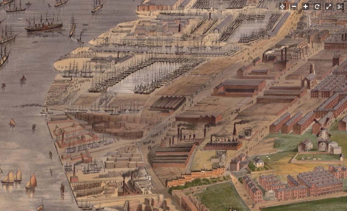


One thought on “A history of the Dingle, Part Four: Industry in Toxteth Park”